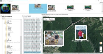
Photo Album GPS Mapping Tool
Photo Album GPS Mapping Tool is a free program for Windows developed by Reverse Engineering ConsultantsLLC. It falls under the category of Photography software. This tool offers users the ability to map GPS coordinates onto photo albums, enhancing location-based organization and visualization of images.
Top Recommended Alternative
With Photo Album GPS Mapping Tool, users can easily geo-tag their photos, creating a visual representation of where each photo was taken. This feature is particularly useful for photographers, travelers, and anyone who wants to add a geographical dimension to their photo collections. The program provides a simple and intuitive interface for users to manage and view their geo-tagged photo albums seamlessly.